




 ...not traffic sewers
Location: The intersection of Belgrade Avenue, Corinth Street, and Robert Street in Roslindale, a.k.a, Eagan Square, a.k.a. Alexander the Great Square (
MAP)
Year of Urban Fabric Restoration: 2007
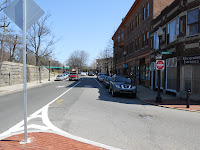
Photos: Clockwise around the intersection, showing the view up Belgrade Avenue back toward the turn at South Street, then the Corinth Street islands, up Belgrade toward Walworth Street, then across and back down Belgrade.
The Story: I said at the end of my last post that this blog has a soft spot for incremental change, and here's an absolutely prime example at the neighborhood scale. We're back again in Roslindale Square, at its southwestern gateway, just after the point at which Robert Street comes under the MBTA Needham Line trestle and meets Belgrade Avenue and Corinth Street. This intersection has a veteran's memorial name of Eagan Square, but there's a second, more recent designation as Alexander the Great Square. That's a nod to the community's still strong Greek presence, as evidenced by Alexander the Great Park, which has a bust of the great man at its center.
Until this intersection took its current form about 3 years ago, it was one of the very worst in the neighborhood, from the perspective of both cars and pedestrians. As a driver, it was hard to know who exactly had the right-of-way and the massive expanse of pavement without much definition left it hard to know exactly where the travel lanes were supposed to be. As a pedestrian, it felt like a free-fire zone: far too wide, with poorly located crosswalks that just left you hanging out there.
The new configuration, shown in the pictures and in my sketch below, is far, far better. The two tiny islands have been widened and extended. The cross-walks are now manageable in length. The main construction material for the islands is brick, with granite curbing. The two largest elements have green space within them. A public art installation is reportedly awaiting Boston Civic Design Commission approval and could be installed this year. The traffic pattern is clear, with well-defined through and turning lanes. The cars now know where to go, and so do the people. Everyone is being paid some attention.
I am embarrassed to say that, even though this is just blocks from my house and we lived here well before the intersection was reconfigured, I have no idea who exactly is responsible for making this happen. Responsibility for the intersection lies with the Boston Transportation Department, so ultimately it had to be their project. But I don't know who in the community advocated for the change. Whoever that person is, they deserve heartfelt thanks. And BTD is to be commended for implementing a design that is a far cry from what has been done to our streets and intersections for too much of the last 60+ years.
Which brings us to the teachable moment portion of this post. It is a sad fact that, on the whole, our country decided in the post-war period to delegate virtually complete control over our streets to traffic engineers whose sole goal was to move more vehicles at higher speeds all the time, everywhere. Streets and travel lanes were widened. Private property was taken to facilitate that widening. Sidewalk widths were reduced or sidewalks totally eliminated. Off-street parking was reduced or banned outright. Pedestrian street crossing times were reduced and vehicle signal phasing increased. And the design of most of what was actually built was wholly unsatisfactory or just plain ugly. In short, far too many streets -- the connective tissue that make up the vast majority of our public realm -- were radically impoverished, turned from places that people could enjoy spending time in to places to be avoided at all costs. In the words of more than one commentator, those streets had simply become "traffic sewers." All of this is to say nothing of the federal interstate construction boom of the 1950s-1970s, that plowed through and gutted too many urban neighborhoods to mention them all by name. Being from Brooklyn, all you have to say to me is "Sunset Park" and I immediately think of the Gowanus Expressway, an elevated highway built in the early 1940s that cut that neighborhood in two and separated it from the water. Perhaps the best piece of writing on the phenomenon of interstate highway construction in urban areas is Robert Caro's chapter on "One Mile" of the Cross-Bronx Expressway in The Power Broker, his seminal biography on Robert Moses. Worth reading again even if you've read the book before.
I am overstating the point slightly here. Not every traffic engineer wanted to pave over paradise or obliterate urban neighborhoods, and not every street was turned into a high-speed nightmare. Plenty of great neighborhood streets, as well as parkways and urban boulevards survived. A lot of that was the result of an active citizenry -- Jane Jacobs being probably the most famous active citizen given her well-publicized fights with Moses over Washington Square Park and the Lower Manhattan Expressway [for an excellent treatment of that dynamic, check out Anthony Flint's Wrestling with Moses, reviewed in the New York Times here] -- that fought the freeway revolt in the late 1960s and early 1970s. Some of it was the sheer amount of good urban fabric that our country has been blessed with. There simply wasn't enough time and money while the game was really on to screw up everything. Over the last 20 years, the pendulum has swung strongly back toward treating our streets like valuable, critically important shared spaces. It is no coincidence that form-based coders devote a lot of time and energy to the design of the streets and related open spaces that become the framework for new neighborhoods. If you want to a satisfying built environment, you need to have the streets and the buildings working together. If either component fails to behave, the place you want will not happen. Great strides have been made, to the point where my observation is that resistance to more complete streets often comes from a public distrustful of change in general and of professional traffic engineers, urban designers, and planners in particular, not from those professions themselves. The new Alexander the Great Square shows that the end result is well worth overcoming whatever obstacles are encountered along the way.
RTUF sketch of the Restored Urban Fabric: It's a little hard to tell just how much of an improvement the current configuration really lis. There was just way more car-reserved pavement at this intersection than remotely made sense.

RTUF Note: This post has been modified after initial publishing to correct certain typos and grammatical errors and to add photos of the detail of the new traffic islands and of the bust of Alexander the Great that is located in the adjoining park. -- ML


 Posts
Posts

